For the mineral owner & manager
Know exactly what you own.
Ownership to the fraction — mineral, royalty, and surface — with the flowchart that shows how it came to be. Roll every tract up into one portfolio so an owner or manager can see their whole position at a glance.
- Mineral owner · Manager
- Own
- Part of the Landspect suite
What it does
From a single tract's ownership to a whole portfolio.
Holdings rolls every tract you own into one portfolio — mineral, royalty, and surface interests down to the fraction, with net mineral acres totaled across the whole position. Fill it without running title: import a spreadsheet of your interests or add tracts by hand. When you do run title, the reviewed chain resolves to exact ownership and renders the flowchart that explains it — feeding the same portfolio.
Where it stands
This module is in active build — the core view is live today and the full workspace is rolling out.
Ownership to the fraction
Mineral, royalty, and surface interests resolved precisely from the chain — the fractions add up because the math is deterministic.
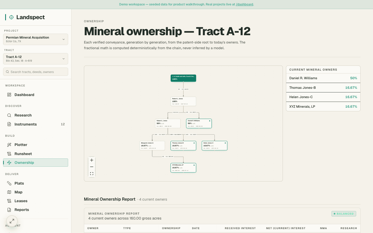
Ownership flowchart
A visual chart of how today's ownership came to be — conveyances, reservations, and heir branches laid out clearly.
Owner portfolio
Roll every tract an owner holds into one position — net mineral acres, counties, and operators totaled across the whole book. Import a spreadsheet or add tracts by hand; no runsheet required.
Lease status
Flag which interests are leased, open, or held by production so nothing slips through the cracks across a large portfolio. (Planned alongside the portfolio dashboard; lease status lives in Runsheets today.)
Revenue context
Tie interests to the revenue they generate for valuation and management decisions. (Planned alongside the portfolio dashboard.)
Want it in your workflow?
We are bringing firms in by wave. Tell us about your work and we will reach out.
- Ownership to the fraction
- Ownership flowchart
- Owner portfolio
What we deliver
The runsheet, the flowchart, and the ownership report.
Without the Excel.
The three deliverables every landman ships today, without the spreadsheets, duplicate data entry, or manual ownership math. Upload an OCR-readable deed, review the extraction, and approve the results. Landspect updates the runsheet, redraws the ownership flowchart, and recalculates ownership interests automatically, while the landman stays in control. Export to PDF, Excel, KML, DXF, or a complete submission package.
Project
W. R. Aldridge Survey, A-21 — Tract 3
156.40 surface ac · San Augustine County, Texas
Generated by Landspect · Reviewed by RPL
Run date · July 15, 2026
Title scope · Mineral
Runsheet · Abstract of Title
4 processed instruments · chain clean back to patent
| # | Grantor | Grantee | Instrument | Recording | Dates | Notes / Effect |
|---|---|---|---|---|---|---|
| 01 | State of Texas | John A. Smith | U.S. Patent | Vol 1 / Pg 18 Land Grants | Mar 22, 1923 filed Apr 14, 1923 | All surface and mineral estate, by patent. balance · Smith — 100% |
| 02 | John A. Smith, et ux | Robert C. Jones, et ux | Warranty Deed | Vol 14 / Pg 218 Deed Records | Mar 12, 1947 filed Mar 15, 1947 | Conveys all right, title and interest in 156.40 ac. balance · Jones — 100% |
| 03 | Robert C. Jones, et ux | C.L. Williams | Mineral Deed | Vol 47 / Pg 503 Deed Records | Aug 4, 1962 filed Aug 19, 1962 | Grantor reserves an undivided 1/2 of the mineral estate; conveys remaining 1/2 to grantee. balance · Jones — 1/2 mineral · Williams — 1/2 mineral |
| 04 | Estate of Robert C. Jones | Heirs of Robert C. Jones (3) | Affidavit of Heirship | Vol 89 / Pg 14 Probate Records | Oct 22, 1971 filed Nov 8, 1971 | Intestate descent of decedent's 1/2 mineral interest equally among three named heirs. balance · Williams — 1/2 · 3 Jones heirs — 1/6 each |
Curative status
No outstanding curative items. Chain is unbroken from the 1923 patent to current ownership. Reservation arithmetic ties to 100% with no rounding remainder.
Reviewed by Registered Professional Landman
Signature on file · seal pending delivery
DEEDS PROCESSED
4
CURRENT OWNERS
4
MINERAL ACRES
156.40
- Reviewed instruments drop into the runsheet in chronological order.
- Fractional interest math runs automatically on every conveyance.
- The MOR sums to 100% or surfaces the curative flag explaining why it doesn't.
- One-click export to PDF, Excel, KML, DXF, and the full submission ZIP.
The rest of the suite
One login, the whole land lifecycle.
- Beta
Landspect Scout
Lasso an area on the map, see every parcel by lease status, export a call-ready acquisition list.
Explore - Beta
Landspect Plotter
Turn a deed's metes-and-bounds or a section/aliquot description into a closed, plotted tract.
Explore - Beta
Landspect Title
Walk the chain of title instrument by instrument into the abstract and the MOR deliverable.
Explore - In build
Landspect Operations
Lease and obligation administration — terms, rentals, division orders, payments.
Explore - Beta
Landspect GIS
Turn shapefiles and ArcGIS packages into a live, shareable, clickable map.
Explore
Get started
Get started with Landspect Holdings.
Create your account and put it to work on real deeds today.